|
HURRICANE SEASON PREDICTION
A weak El Nino and cool Atlantic waters are two limiting factors that affect hurricane development. El Niño
phase and intensity show signs of the most active times of August, September and October. This would lead to less frequent episodes of wind shear across the
basin, which affects tropical cyclone development and intensification.
The Atlantic hurricane season runs from June 1st to November 30th
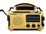
Communication is critical during and after a Hurricane. Besides a Radio you should also have a Cell Phone.
This Web Site is a Public Service We specialize in Beach and Waterfront Florida Real Estate for over 25 years. We survived intact from the impact of Hurricane Irma. The category 2 Hurricane came within 10 miles of our home. Feel free to contact us at our web sites
Waterfront Florida Home Waterfront Florida
Condo
June 2018, the University of Arizona forecasting model predicts a below-average number of hurricanes for the 2018 hurricane season. UA researchers are predicting 4
hurricanes, two of which will be major hurricanes. UA prediction is among the lowest of all forecasts. In 2017, the UA's forecast was among the highest - 11 hurricanes
with 6 majors it was closest to hitting the mark.
A main factor in this year's prediction is the sea surface temperatures over the Atlantic.
Tropical Atlantic Ocean surface wind from east to west is stronger than in most years, which means a stronger wind shear, which usually reduces hurricane activities.
Oct 2018, Hurricane Michael is the 13th named storm and 7th hurricane of the 2018 Atlantic hurricane season.
2018 Hurricane Florence was not a threat to Florida - Heavy storm surge and coastal flooding battered the east coast North Carolina areas
The U.S. continues to recover from an estimated $285 billion in damages caused in 2017 during one of the most catastrophic hurricane seasons in history.
We survived intact from the impact of Hurricane Irma. The category 2 Hurricane came within 10 miles of our home.
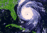
Hurricane Irma in September 2017 went up the west coast of Florida but far enough away from the warm Gulf of Mexico waters when it reached the Tampa Bay
Florida area. Irma blasted Key West as a Category 4 Hurricane and moved over Naples and Fort Myers. As it moved over land it decreased to a Category 3 and then at Cat 2 as it neared
Tampa Bay. Most of the Tampa Bay 4 county area of Pinellas, Pasco, Hillsborough and Manatee had a low Cat 2 to a Cat 1 effect. Most of the damage was from winds up to 100mph. Flooding
was not as bad as earlier predicted as Irma went up the middle of Florida. As of Sept 26th 2017 - Hurricane Irma resulted in 335,000 insurance claims in property losses the state Office
of Insurance Regulation reported.
The Atlantic hurricane season extends from June
1st to November 30th.
Many factors
must be present for a hurricane to develop and intensify - Ocean temperature at
a minimum of 80 degrees to a depth of at least 150 feet. 2017 Florida Hurricane Info - The current warmer sea surface temperatures tend
to fuel hurricanes as they move across the ocean. The climate models are showing considerable uncertainty.
Forecasting is not an exact science. Which forecast model should you trust?
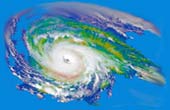
Hurricane Tracking
The European Model
Hurricane or NOT Items that you should always have available. Non-electric can opener, flashlights
and batteries, portable radios, Candles, dry food, canned food, bottled water. Save large plastic jugs and store in garage. Fill 3/4 with water and put in freezer at least 2 days before
a Hurricane is forecast to approach Florida. The frozen water jugs will keep your food in the fridge and freezer cold for at least 3 days. Our food stayed useable during Hurricane Irma.
Coleman portable cook stove under $45 plus fuel at WalMart and other stores. We used it and had hot food.
A Hurricane season can deliver many storms, but have little impact, or deliver few storms and have one or more hitting the U.S. coast with major
impact.
August 25- 2017 - Hurricane Harvey blasts Texas and surrounding areas with floods and extensive damage
2016 Florida Hurricane Info - The National Oceanic and Atmospheric
Administration's updated outlook predicts 12 to 17 named storms, including five
to eight hurricanes, two to four of which could be "major." On average, the U.S.
gets 12 named Atlantic storms a season, including six hurricanes, three of them
major.
Hurricane Hermine was the first hurricane to hit Florida in 11 years.
The 2015 Atlantic hurricane season was one of the least active in
decades. 8/29/2015 - Tropical Storm ERIKA dissipates. Wind shear in the
Caribbean Sea and the mountains of Hispaniola weakened TS Erika. The mass split
in two near Cuba and weakened into a tropical wave.
The 2014 hurricane season had a below average number of named storms
and hurricanes. Statistical analysis suggested 9 to 11 named storms for 2014,
including five hurricanes, one or two of which are predicted to reach major
Category 3 or stronger hurricane status. The forecast proved to be not very
accurate.
The 2013 Atlantic hurricane season had the fewest number of hurricanes since
1982. 2013 had one of the strongest El
Nino events on record. The tropical Atlantic was cooler than normal.
Forecasters had predicted that the 2013 Atlantic hurricane season would be more
active than normal. Records going back to 1851 show there had been only 17 years
when the first Atlantic hurricane formed after September 4. For the first time
in 11 years there has not been a Hurricane in the Atlantic up to that time of
the year. The first hurricane of the 2013 season was named Humberto, it formed
far out in the Atlantic on Sept 11th, then decreased to a Tropical Storm.
Hurricane Ingrid formed in the Gulf of Mexico on Sept 14th 2013 and weakened to
a Tropical Depression as it landed on the coast of Tampico Mexico on 9/16. The
first Tropical Storm of the 2013 season was Tropical
Storm Andrea with highest wind speed of 65mph. It also caused tornado activity
in south west Florida. No major damage as it moved across north Florida and into
the Atlantic Ocean. The second Tropical Storm named Chantal decreased into a
tropical depression. Air temperatures from the Caribbean to Africa was warmer
than normal which has reduced instability in the atmosphere that drives storm
development. Also, dry air was pulled off Africa into the Atlantic which also
affected storm activity.
Persistent unfavorable atmospheric conditions to hurricane
formation over the Gulf of Mexico, Caribbean Sea, and tropical Atlantic Ocean
was the reason that 2013 is ranked as the sixth least active Atlantic hurricane
season since 1950 in terms of named storms and hurricanes. Air temperatures from
the Caribbean to Africa was warmer than normal which has reduced instability in
the atmosphere that drives storm development. Also, dry air was pulled off
Africa into the Atlantic which also affected storm activity. Forecasters had
predicted that the 2013 Atlantic hurricane season would be more active than
normal.
2012 - Sandy wreaked havoc - Storm surges,
heavy rain and devastating winds blasted the U.S. East Coast
Hurricane Sandy merged with a winter system from the West and both were fed by
cold air from Canada. Some called it a "super storm" or "perfect storm". When
the center of Sandy hit land off the New Jersey Coast, on October 29th, the
impact was felt across an area more than 900 miles wide. New York City sustained
the greatest damage. Wall Street shut down, subway tunnels flooded, power
failures were monumental and tragic loss of life.
Debby was the fourth named storm of the 2012 Atlantic hurricane season (June23)
Above average rainfall in Florida replenished water supplies and most water
shortage warnings were lifted after Tropical Storm Debby drenched Florida
counties.
An El Nino effect - warms the surface waters in the tropical Pacific
and has far-ranging effects around the globe. It creates wind shear that makes
it harder for storms to grow into hurricanes in the Atlantic-Caribbean basin. In an average year, there are 11 tropical storms, 6 hurricanes and
2 major hurricanes in the Atlantic, Caribbean and Gulf of Mexico.
The 2011 NOAA hurricane forecast predicted 12 to 18 named
storms and 6 to 10 hurricanes with 3 to 6 possible major hurricanes. Irene was
the 1st Hurricane of the 2011 Atlantic Hurricane Season. There were 19 named
Tropical storms and 3 Hurricanes - Irene, Katia and Rina. Hurricane Maria
followed a similar track as Hurricane Katia. Both posed no threat to Florida or
the U.S. East Coast. The predicted forecast models were accurate. In early
August Hurricane Dora developed in the Pacific Ocean off the Mexico Coast but
quickly diminished in intensity and posed no threat to the U S.
The U.S. East Coast from North Carolina to New York had the most severe weather
- especially from Hurricane Irene. Florida once again did not have any
destructive weather or hurricane land fall.
Many factors must be present for a
hurricane to develop and intensify - Ocean temperature at a minimum of
80 degrees to a depth of at least 150 feet.
A Hurricane Watch means that hurricane conditions are possible within the watch
area. A watch is typically issued 48 hours before
the anticipated first occurrence of tropical-storm-force winds...conditions that
make outside preparations difficult or dangerous.
A Tropical Storm Warning means that tropical storm conditions are expected
somewhere within the warning area within 36 hours.
2011 - Hurricane Irene
came ashore near North Carolina's Cape Lookout around 7:30 a.m. EDT Saturday as
a Tropical Storm. Irene dropped in intensity to 65 mph before making landfall in
New York City at about 9 a.m. Sunday. The National Hurricane Center official
track forecast for Irene was pretty accurate for landfall locations. Irene had
roared across the Caribbean with winds of up to 120 mph. Irene produced rainfall
accumulations of 6 to 12 inches with isolated amounts of 20 inches through the
mid-Atlantic states into eastern New York and New England. Widespread flooding,
life-threatening flash floods and significant uprooting of trees due to
rain-softened grounds are reported. Irene may cost insurers as much as $3
billion to cover U.S. damage, with overall economic losses of $7 billion. There
have been over 45 storm related deaths reported so far. Over 2.5 million on the
East Coast lost power.
During Hurricane Katrina in 2004 stores closed as looters ran wild. Grocery
stores typically only carry 3-4 days worth of food that's would be gone in a few
hours during a crisis through buyers hoarding or criminal looting. Prepare in
advance.
News Weather Archives
Hurricane Katrina
In 2010 there were a total of 19 named storms. Luckily, none of last years 12
hurricanes hit the United States. The 2010 season was an unusual and highly
active season. Damages and loss of life were far below what one would expect
from so much activity. The year is most remembered for what didn't happen.
Luckily a full fledged hurricane did not slice into the BP Deepwater Horizon oil
spill, nor did a devastating hurricane cause massive loss of life in Haiti's
vulnerable earthquake zone. However, 2 hurricanes Karl and Alex did billions of
damage to Mexico. It was the 5th year in a row
that Florida did not receive a major hurricane strike.
DID YOU KNOW
- Many factors must be present for a hurricane to develop,
they include: Ocean temperature must be a minimum of 80 degrees to a depth of at
least 150 feet. The lower layer of the atmosphere (troposphere) must contain a
large degree of high humidity. The difference of the wind speed between the
lower and upper atmospheres must not exceed 20 miles per hour. Thunderstorm
activity must be present to start the circular spinning action and create an
upward flow of air. Wind speed begins to speed up near the center of the
thunderstorm center, and if barometric pressure drops, more air is sucked up
into the core of the storm and wind velocity begins to increase. If wind speed
increases to 74mph (the minimum velocity for hurricane classification), an "eye"
will generally begin to form, giving birth to a hurricane.
The loop current has less effect on the west coast of
Florida keeping more than 100 miles off the coast.
Concerning the 2011 BP Oil Spill in the Gulf and West Coast of Florida where the
properties are located not to be affected -
Review The Loop Current
Protect your home. Get a professional inspection and strengthen
areas prone to storm damage. Take photos and save them with all receipts in a
safe place. Contact your insurance agent about rebates for any work done to
fortify your home, such as hurricane windows, doors and protective roofing.
The official Atlantic hurricane season is from June 1st through November 30th.
Many factors are needed for a hurricane to develop, such as - the Ocean
temperature must be a minimum of 80 degrees and depth at least 150ft.
Current Gulf of Mexico water temperatures 85 to 88 degrees from Key West to
Tampa Bay.
2010 Weather News - Alex was the first
Atlantic Hurricane of the season and reached a category 2 in intensity. It made
its way over the Gulf of Mexico and slammed into Mexico with 100 mph winds
Wednesday night June 30th and then dissipated as it moved over land. Wave action
from the hurricane only caused a minimal effect as it pushed some of the top
slick from the oil leak area in the Gulf closer to the shores in Louisiana,
Alabama and Mississippi Hurricane Danielle and Earl are the second and third
hurricanes of the season and remained out in the Atlantic. Danielle remained out
in the Atlantic and caused no damage to the U.S. Earl
diminished from a hurricane to a tropical storm as it made landfall near Western
Head Nova Scotia with sustained winds of 70 mph.
Tropical Storm Hermine got up to 70 mph just under category one status and
slammed into Mexico's northern Gulf Coast near the U.S. border with winds of 60
mph, lashing Mexico and southern Texas with heavy rains that caused some flash
flooding.
For the first time in twelve years, we had a rare triple threat in the Atlantic
-three simultaneous hurricanes. Hurricane Karl joined Hurricanes Igor and Julia
in the steadily expanding Hurricanes of 2010 club becoming the sixth hurricane
of the season. The last time we had three simultaneous hurricanes in the
Atlantic was in 1998.
Igor made landfall at Newfoundland, Canada with heavy rain and winds near
hurricane force. Hurricane Danielle and Earl were the second and third
hurricanes of the season and remained out in the Atlantic and followed a similar
path as Igor and Julia.
The activity for the 2010 Atlantic hurricane season has an average of 10 names
storms, 6 hurricanes, and 2 intense hurricanes. For 2010 NOAA
projected a 70% probability of : 14 to 23 Named Storms (top winds of 39 mph +,
including: 8 to 14 Hurricanes (top winds of 74 mph +), of which: 3 to 7 could be
Major Hurricanes (Cat 3, 4 or 5; winds at least 111 mph). Richard is the 10th
hurricane of the 2010 Atlantic hurricane season tied for sixth place for most
hurricanes in an Atlantic hurricane season. The year's 17 named storms also
ranks 6th most in history; Atlantic hurricane season records go back to 1851.
2010 Atlantic Hurricane season - NOAA predicted a 70 percent probability of the
following ranges: 14 to 23 Named Storms (top
winds of 39 mph or higher, including: 8 to 14 Hurricanes (top winds of 74 mph or
higher), of which: 3 to 7 could be Major Hurricanes (Category 3, 4 or 5; winds
of at least 111 mph).
It
was the fifth year in a row that Florida did not receive a major hurricane
strike. The last major hurricane to hit the United
States was Wilma, which first struck southwest Florida as a Category 3 system in
2005. Since the mid-1800s, when records were first kept, the United States has
never gone six years without a major hurricane strike.
Many factors must be present for a hurricane to develop, they include:
Sea temperature must be a minimum of 80 degrees to a depth of at least
150 feet.
The lower layer of the atmosphere must contain a large degree of high humidity.
The difference of the wind speed between the lower and upper atmospheres must
not exceed 20 miles per hour. Thunderstorm activity must be present to start the
circular spinning action and create an upward flow of air near the center of the
thunderstorm center, and if barometric pressure drops, more air is sucked up
into the core of the storm and wind velocity begins to increase. If wind speed
increases to 74mph (the minimum velocity for hurricane classification), an "eye"
will generally begin to form, giving birth to a hurricane.
On April 7, 2010, Colorado State University
issued its annual report on the year's hurricane forecast predictions.
Forecasters predict above average Atlantic hurricane-season. University
forecasters William Gray and Phil Klotzbach each stated that El Nino conditions
will likely dissipate by summer. In addition they believe that the warm tropical
Atlantic sea surface temperatures will not drop and will remain at the current
temperatures. These temperatures have reportedly been much warmer than usual.
Have a plan of action to protect against hazards. A family
plan should include knowing the risks in your area, locating safe areas in the
home or evacuation centers, setting a contact location where family members can
meet, making plans for pets, storing nonperishable food and other emergency
items, and using a NOAA radio.
Many factors must be present for a hurricane to develop and
intensify, they include: Ocean temperature must be a minimum of 80 degrees to a
depth of at least 150 feet.
In a typical season,
there are about 11 named storms, of which two to three impact the east or gulf
coast of the US.
2009 Archives - The North Atlantic hurricane
season overall in 2009 ranks as the slowest since the El Nino year of 1997.
Bill was the first Atlantic hurricane and did not affect Florida. Hurricane Ida
fizzled out because the Gulf water temperatures were not warm enough.
Hurricane Categories are based on sustained winds (1)74-95 mph (2)96-110
(3)111-130 (4)131-155 (5)over 155 mph. The official
Atlantic hurricane season is from June 1st through November 30th.
Forecasters predicting an above average 2010
Western Atlantic Hurricane season due to expected warm ocean temperatures.
In a typical season, there are about 11 named storms, of which two to three
impact the east or gulf coast of the US. AccuWeather Hurricane Center
meteorologists are predicting 16 to 18 tropical storms, 15 of which would be in
the western Atlantic or Gulf of Mexico, and therefore a threat to land. They
predict seven landfall - five hurricanes, and two or three of the hurricanes
will be major landfalls for the U.S.
Tips after a Hurricane Do not examine your
home for damage with matches, candles, or other other "flame based" lighting.
Use flashlights. Avoid downed power lines. If you stored water in open
containers such s bathtubs, do not drink water without purifying it first.
2009 Hurricane Season including 2008
and 2010 -Tropical Storm Names & 2009 Hurricane Names -Ana, Bill, Claudette,
Danny, Erika, Fred, Grace, Henri, Ida, Joaquin, Kate, Larry, Mindy, Nicholas,
Odette, Peter, Rose, Sam, Teresa, Victor, Wanda
For 2008 NOAA had predicted a near normal Atlantic Hurricane Season with a 65%
chance of 12 to 16 named storms, including 6 to 9 hurricanes and 2 to 5 major
hurricanes. An average season has 11 named storms, including 6 hurricanes. Only
Fay slammed the state of Florida with heavy rains. The 15 other named storms
spared Florida. 2008 Named Tropical Storms and Hurricanes
were Arthur, Bertha, Cristobal, Dolly, Genevieve, Edouard, Fay, Gustav, Hanna,
Ike, Iselle, Josephine, Kyle, Omar and Paloma
August 2008 Tropical Storm Fay -
caused severe water shortage for a 16-county region of Florida and parts of
Georgia. Rainfall from from 17 to 25 inches for Florida and Georgia was
reported. Areas of flooding with accumulations up to 30 inches caused major
damage. While hurricane losses in Florida were minimal this year, 2008 was the
fourth costliest hurricane season on record - $21 billion in U.S.-insured
damages, according to the ISO's Property Claim Services.
Florida Hurricane Strike Statistic Probabilities - Cape
Coral Florida 1 in 11 ---- Tampa Bay Florida (st
pete, clearwater area) 1 in 25
Jun 1, 2006 - It leaves residents in hurricane-prone areas feeling
shell-shocked. Cape Coral insurance agent Brad Carlock knows of people who take
out long-term loans to pay their annual insurance bills. Oct 20, 2005 -
Hurricane Charley that came within 10 miles of Cape Coral and caused significant
damage. Damage estimates in Cape Coral topped $600 million and 41 percent of the
homes here suffered some damage. Aug 14, 1992 - . Hurricane Andrew, which caused
billions of dollars of damage in south Florida. ... Heavy damage was reported in
Cape Coral
The Top 10 States that have had Major
Hurricane strikes are Florida with Texas a close second, Louisiana, North
Carolina, Mississippi, Alabama, New York, South Carolina, Connecticut and Rhode
Island (hurricane strikes chart)
The Atlantic hurricane season is officially from 1 June to 30 November.
Chart From 1950 to 2004 in the United States
Major Hurricane Land Strikes
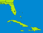
Tracking Path Images
Tropical Storm Fay
Hurricane Gustav
Before you purchase area Real Estate - get updated Information on Tampa Bay Area
Flood Zoning, Property Insurance, etc.
If
your mortgage company and/or insurance agent claim that your home is in a
Special Flood Hazard Area, this link recommends you perform a flood risk
analysis.
What you should know about the
National Flood Insurance Program
Insurance experts sound alarm that Florida may be ill-equipped to pay future
storm claims Florida Home Insurance
News
Florida Residents and Flood Insurance Information from
FEMA -Federal Emergency Management Agency
SEARCH HOME PROTECTION SERVICE COMPANIES FOR INSTALLATION OR
REPAIRS SAFETY GLASS WINDOWS DOORS GARAGE DOORS
Real Estate Owners - Home Window Protection
- Temporary Shutters, permanent shutters
and impact resistant windows
Rollshield.com
Homes
Window Protection - Window clips are one of many inexpensive ways to
protect your real estate and windows from high winds and airborne debris. They
install in minutes and slide on the edge of the plywood which is inserted into
the exterior window casing. Plywood can be removed without tools.
Hurricane Window Clips
Florida Real Estate Insurance Info-
In 2002, the Florida Legislature passed a law that combined the Florida
Residential Property and Casualty Joint Underwriting Association (FRPCJUA) and
the Florida Windstorm Underwriting Association (FWUA). This resulted in the
creation of Citizens Property insurance Corporation (Citizens), which more
efficiently and effectively provides insurance to, and serves the needs of,
homeowners in high-risk areas and others who cannot find coverage in the open,
private insurance market. Web Sites
http://www.citizensfla.com
Florida Homeowner Referral Program for Insurance
Hurricane Strike Statistics and Probabilities Map
Strengthen your home or condo with an inspection and earn insurance rebates
Atlantic hurricanes often form to the west or northwest of the African
equatorial coast. Prevailing wind currents generally cause them to travel in a
westward or northwestward direction, making the Caribbean Islands usually
vulnerable. Hurricanes can develop in almost any of the world's oceans, but
generally form in the tropics and the Gulf of Mexico. Tampa Bay Florida Flood
Zones
FEMA General Info
Pinellas County Flood Zones
FEMA Flood Maps Pinellas County
|